Amherst Hydrology from urban planning to restored golf course

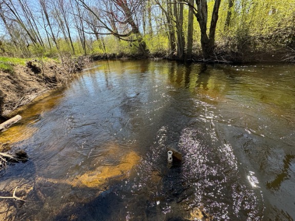
The Tan Brook is a very small stream the runs through the center of Amherst, through the middle of UMass, and out to the Connecticut River.  Have you ever seen it? Not likely, or you might not know it if you did, since the Tan Brook is confined to sewer pipes along much of its length. How about Hickory Ridge golf course? The Town of Amherst recently purchased this section of the undammed Fort River’s floodplain and is slowly restoring tis wetland and stream health. 

For this independent study project we will assist the Town of Amherst with assessing how much water flows in Tan Brook and the Fort River, as well as how deep the water table is below the floodplain. We will measure streamflow at Tan Brook and Hickory Ridge using the USGS standard procedure for the velocity-area method, utilizing a wading rod (for stream depth) and acoustic flow velocity meter (water velocity). 

Depending on the project length, we will make these measurements once, twice, or multiple times throughout the year to (a) determine a flow rate on specific dates, and (b) to develop a rating curve (stage vs. discharge relationship) from different flow rates, allowing us to extrapolate flow rates from water height throughout the year (if project duration allows), (c) repair broken piezometers at Hickory Ridge, (d) download logger data, and (e) calibrate and plot time series of water level, temperature and estimated streamflow. 

We are looking for an organized, detail-oriented student with good data keeping skills that may be interested in gaining some lab and field experience to help us with this project.  

Name of research group, project, or lab
The Hatch Lab (Morrill Science Center & Fieldwork)
Why participate in this opportunity?

This flexible independent study project allows students to participate in a multi-faceted larger, long-term study. Students will select a component of the project that is of particular interest to them, and while working on that piece, contribute to team measurements and the larger research project. Group fieldtrips (and adventures) to field sites will provide the opportunity for students to learn many different techniques. Students can choose 1, 2, or 3 credits (an average of 3, 6, or 9 hours per week), to participate on a volunteer basis, receive practicum/ praxis credits (for the Environmental Science or other major requirements), or in some cases to be paid hourly for research assistance (particularly during the summer, or as part of the LeeSIP or CAFE Summer Scholars programs).

Logistics Information:
Field(s) of Study
Earth Systems
Ecology and Environmental Sustainability
Environmental Science
Geology
Natural Resources Conservation
Plant and Soil Science
Science (Interdepartmental)
Student ranks applicable
Freshman
Sophomore
Junior
Senior
Open to Honors Thesis Work
Student qualifications

Responsibilities/qualifications: The student(s) must have the ability to work independently and be responsible. Students interested in gaining some lab and field experience must be organized, detail-oriented and possess good data management skills. Field work can involve long days, walking several km over uneven ground without a trail, ground is often very uneven and wet. Poison ivy, sun or cold, ticks and other outdoor inconveniences are common. 

Overnight accommodation and transportation is included but students may need to bring some food. Students must have the ability to work independently and be responsible, and the lab instrumentation requires acute attention to detail for successful measurements. Enthusiasm for a novel project and ability to work in a diverse team are also a plus! 

Time commitment
1-4 h/wk
5-7 h/wk
8-10 h/wk
Position Types and Compensation
Credit for Research and Teaching
Paid - General
Unpaid - Volunteer
Number of openings
2
Techniques learned

Students will Assist the Town of Amherst with the hydrology of local rivers and wetlands. Specifically, assist with (one or more of) the following: (1) measure streamflow at Tan Brook and Hickory Ridge (2) calculate flow rate on specific dates, and (3) to develop a rating curve (stage vs. discharge relationship) from different flow rates, allowing us to extrapolate flow rates from water height throughout the year (if project duration allows), (4) repair broken piezometers at Hickory Ridge, (5) download logger data, and (6) calibrate and plot time series of water level, temperature and estimated streamflow. 

When in the field, the student will make measurements and collect data contributing to the larger research projects, as well as their specific topic of independent study, including GPS data, water level measurements, streamflow measurements, and other measurements. 

Project start
Fall Semester 2026
Contact Information:
Mentor
cehatch@umass.edu
Extension Professor, Earth, Geographic and Climate Sciences Department, UMass Amherst
Name of project director or principal investigator
Christine Hatch
Email address of project director or principal investigator
cehatch@umass.edu
2 sp. | 9 appl.
Time commitment
1-4 h/wk (+2)
1-4 h/wk5-7 h/wk8-10 h/wk
Field(s) of Study
Natural Resources Conservation (+6)
Earth SystemsEcology and Environmental SustainabilityEnvironmental ScienceGeologyNatural Resources ConservationPlant and Soil ScienceScience (Interdepartmental)